

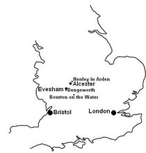
One of the chief features of Bourton is the river, the Windrush. It is a tributary of the Thames. It rises in the Cotswold Hills in Gloucestershire near Winchcombe, northeast of Taddington, which is north of Guiting Power, Temple Guiting, Ford and Cutsdean. It flows south east for 65 km (40 mi). The first 35 miles (56 km) go through Bourton-on-the-Water, by the village of Windrush into Oxfordshire and through Burford, Witney, Ducklington and Standlake. It meets the Thames at Newbridge upstream of Northmoor Lock. It gives its name to the village of Windrush, Gloucestershire.
The name is first attested in an Anglo-Saxon charter of 779, where it appears as Uuenrisc. It appears as Wenris and Wænric in charters of 949, and Wenríc in one of 969. The name means 'white fen', from the Welsh gwyn and the Old Celtic reisko.
The river may still host trout, grayling, perch, chub, roach and dace. It held good populations of native crayfish until at least the 1980s. Its waters were used in cloth and woollen blanket making in Witney from mid seventeenth century. In 2007, it was among many of the district's rivers to flood. It flooded generally but perhaps most acutely in Witney, whose only bridge across the river was submerged. Some decline has been noted, especially in years of duly reported and fined untreated sewage from plants of Thames Water. The river after drier spells sees algae formations.


No comments:
Post a Comment